Automated Detection of Archaeological Sites in High Resolution Remotely Sensed Imagery
Introduction
Automated visual analysis has substantially advanced in recent years, allowing a variety of targets to be automatically detected. Remarkably successful algorithms and technologies have been developed, for example, for face detection and for object detection for autonomous car navigation. In archaeology, on the other hand, the interpretation of remotely sensed images is still the domain of archaeologists visually inspecting the images. Aerial or satellite images may be visually inspected prior to field survey with the goal to identify potential sites to guide fieldwork. Such an approach considerably saves fieldwork time. A large amount of high resolution image data has become available during recent years due to developments of satellite technology. However, a visual inspection of the image data over vast unexplored areas is not feasible. Although human vision is clearly superior to the current state of computer vision, automated screening of large image datasets may offer valuable assistance, guiding and increasing the efficiency of archeological survey [9].
Image processing techniques developed for archaeological applications have been mostly focused on contrast enhancement and automated mapping of known sites. Regarding detection of potential archaeological sites, the widely held belief that the great variation of the archaeological record prevents automated detection has led to a lack of investigations in this field [1]. There are a few case studies trying to identify probable archeological sites based on their spectral properties. Unfortunately, spectral properties are not unique to the sites of our interest and also not consistent from site to site. On the other hand, to our knowledge, there are only few case studies, [2, 3, 4, 5], that aim at the detection of archaeological sites, such as settlement and burial mounds, also using their geometrical features. Most of archaeological studies of this kind are limited to particular archaeological areas without attempts towards wider application. One exception is a work described in [3], where the authors aimed at automated mapping of previously unknown settlement mounds (also called tells) over 23000 square km in northeastern Syria using several sources of satellite imagery with a spatial resolution ranging from 15 to 90 meters per pixel.
Goals
The goal of our project is the development of algorithms for the routine screening of large amounts of remotely sensed images of 0.5m resolution, be they aerial or satellite images, in order to detect archaeological sites. We do not target all kinds of sites of archaeological interest, which is a hardly achievable task, but limit ourselves to architectural remains that are relevant in the context of our project, i.e. ruins of livestock enclosures (see the figure below).
Such structures can be modeled by nearly linear features that meet at approximately right angles. An outcome of the chain of algorithms is a likelihood map indicating the presence of objects of our interest. This map is thresholded at the level that corresponds to an acceptable number of false detections. A specially developed interactive user interface can be further used by archaeologists to effectively and quickly inspect the likelihood map overlaid on the remotely sensed imagery of vast unexplored areas. The algorithms are required to work with areal or satellite remotely sensed images of various terrains and must be robust to illumination changes. Due to the large variability of the appearance of objects of our interest, the cluttered background, low contrasts of partially ruined structures and illumination changes this task is very challenging. Even the detection of easily modeled circular soil structures, studied in [5], had very limited success due to low contrasts and complex terrain.
Although we develop algorithms with a specific archaeological application in mind, they will not be limited to remotely sensed images and can be also used to solve other problems.
Collected data
We use two sources of remotely sensed imagery, aerial ortho-photos and satellite images. Aerial color (RGB) ortho-photos were provided by the Swiss Federal Office of Topography (Swisstopo, Berne) and were acquired in 2005. Satellite images were provided by GAF AG, captured by the GeoEye-1 satellite in September 2011. Both types of images have have a spatial resolution of 0.5m/pixel and cover an area of more than 500 square km of the alpine Silvretta mountain range.
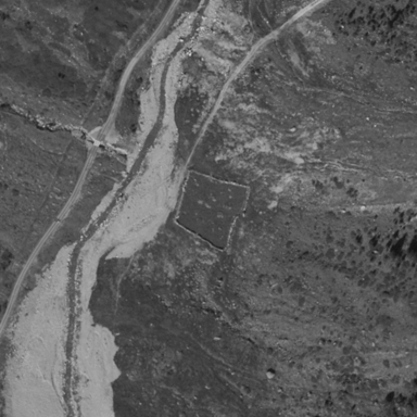
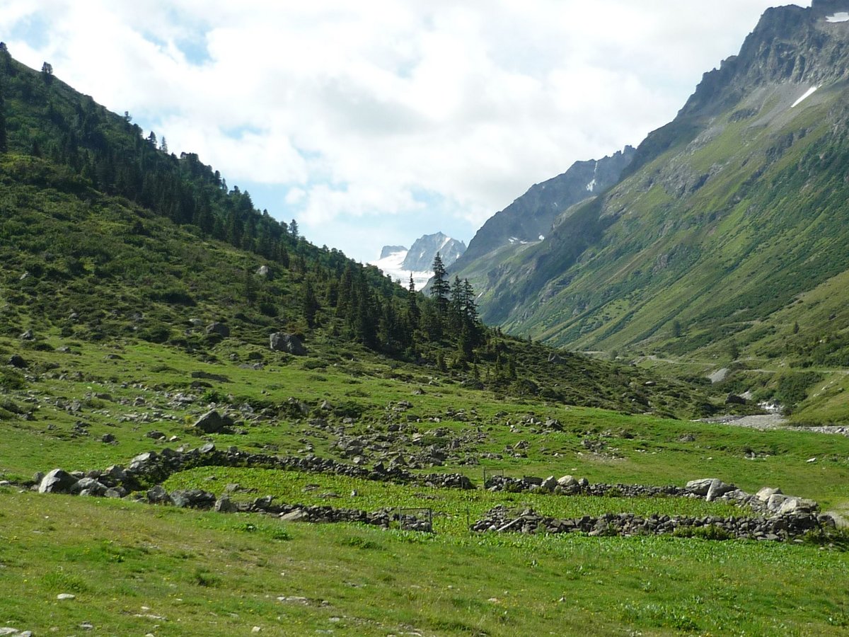
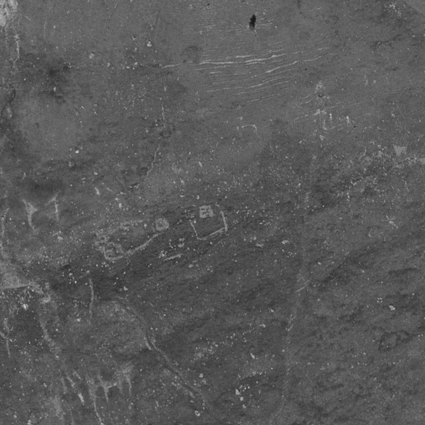
Our work is a part of the Silvretta Historica project that was initiated in 2010 by the University of Zurich, the University of Konstanz and various project partners in the Silvretta region (see [7], [8] and [9]). It is the continuation of an earlier archaeological project in the Silvretta region titled "Rückwege – Alpine Archäologie in der Silvretta". The Silvretta Historica project aims at studying human activity in the Silvretta Alps and at promoting cross-border tourism in this region. During several years of archaeological survey hundreds of archaeological sites were discovered. Among them there are less than 10 well preseved ruins of livestock enclosures and similar number of ruined huts. These structures offer important insights into the origins and historical development of alpine pasture economy in our study area, which is a key research topic of the Silvretta Historica project. The figure above on the left shows an example of one of the best preserved enclosures. On the right one can see a panchromatic satellite image of the same site. We use these representative examples to develop our general strategy and particular algorithms. In a later stage of our project we intend to verify the performance of the developed methods in different alpine areas.
The strategy
To identify objects in remotely sensed imagery one can rely either on spectral or geometrical properties of the objects. Unfortunately, spectral properties are not unique to the sites of our interest and also not consistent from site to site. Therefore we rely on the geometrical properties of objects as the main cue.
There is no unique template that can match the objects of our interest, which are nearly rectangular structures or fragments thereof. These structures are composed of approximately linear walls of different sizes with different proportions. Therefore a basic template matching approach as proposed in [5] cannot be adopted for our task. The small number of examples of sites of our interest also prevents us from using a related approach based on eigen-images learned from the data, as it was implemented in [6]. Moreover, other standard machine learning approaches are also not appropriate, since the variability of objects of our interest requires a much larger database of examples, which is not available in our case. Such a situation, in which only a small number of examples is available (while being large enough to guide human decision making) is not unique to our case, but presents a common problem that needs to be tackled in various machine vision applications.
We are approaching detection of enclosures in the following way. Line segments are firstly extracted by means of a sequence of morphological operators, see [11, 13]. These operators are capable of extracting isolated segments that stand out of a background texture (soil/stone texture). We then search for convex groups of these segments that form a set of long linear features either nearly parallel or perpendicular to each other. The search is performed in a way that enables detection of incomplete or fragmented structures of an approximately rectangular shape, [12, 14, 15].
Using this approach, a large number of features is likely to be extracted in high contrast textured areas, such as urban or forest areas, resulting in high rates of false detections. Since the objects of our interest are usually located in smooth areas, filtering out high contrast textured areas will reduce the number of false detections without affecting sensitivity to true examples. Thus, our strategy also includes a preprocessing step that segments out textured regions from the areas for further analysis (see [10, 11, 13] for details). Such filtering also reduces computational burden.
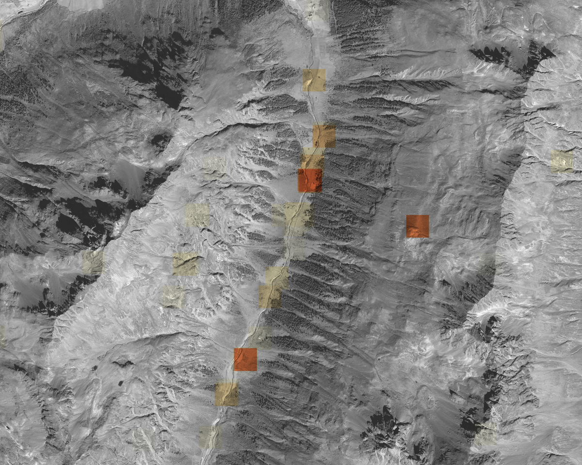
In the validation stage most of the falsely detected sites are rejected by a developed linear classifier that is capable of learning from a large number of negative examples and a very small number of positive examples (objects of our interest), [14, 15]. The operating point of this classifier is set by the user in order to meet a maximal number of acceptable false detections. An example of the 10000x8000 pixel map visualizing the classifier output, which is a likelihood of the presence of structures of our interest, is shown below. Such a map has zero values at most regions. Other regions are ranked by a continuous range of likelihood values (corresponding to changing of hue to the direction of red and increasing saturation of colored squares). The three most saturated redish sites are real livestock ecnlosures detected in the Silvretta mountains. The lowest of the three sites corresponds the enclosure shown above. Most of the other detections with lower likelihoods are false positives caused by occasional alignments of streams, paths, stones, or eroded soil.
In order to be able to quickly verify true detections our methodology also includes a specially developed user interface. It allows a user to explore large images, shows detections and their confidence, and allows to quickly reject numerous falsely detected sites.
The results
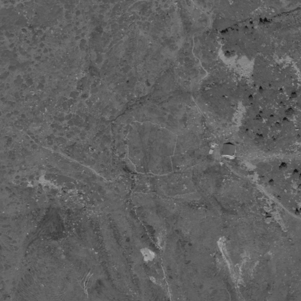
Using our methodology we succeeded to detect hitherto unknown livestock enclosures in the Silvretta Alps. Figure below shows a couple of corresponding examples, see [15] for details.
We also compared our approach with the alternative ones including deep learning that has recently become the state of the art in machine learning. Since in our problem we have only a few representative examples, for our comparison we used pre-trained deep convolutional neural network (CNN) models. Both, the features generated by deep CNNs and the introduced rectangularity-size features fed the linear classifier that was trained using our methodology. The experiments have shown that the rectangularity-size features outperform by a safe margin the deep CNN features for our task [15].
On the other hand our experiments support an assumption that pre-trained deep CNN models can become competitive if the amount of available for training (of the linear classifier) data is modestly enlarged and suitably augmented with artificially transformed examples. This approach can therefore be a promising direction of the future research.
References:
[1] Rosa Lasaponara and Nicola Masini, "Remote Sensing in Archaeology: From Visual Data Interpretation to Digital Data Manipulation," Satellite remote sensing: a new tool for archaeology, Springer Netherlands, 2012.
[2] J. Schuetter, P. Goel, J. McCorriston, J. Park, M. Senn, M. Harrower, "Autodetection of ancient Arabian tombs in high-resolution satellite imagery", International Journal of Remote Sensing, vol. 34, issue 19, pp. 6611-6635, 2013.
[3] Bjoern H. Menze and Jason A. Ur, "Mapping patterns of long-term settlement in Northern Mesopotamia at a large scale," in Proceedings of the National Academy of Science of the United States, pp. E 778-787, 2012.
[4] Bjoern H. Menze, Jason A. Ur, and Andrew G. Sherratt, "Detection of ancient settlement mounds: archaeological survey based on the SRTM terrain model," Photogrammetric engineering and remote sensing, vol. 72, no. 3, pp. 321-327, 2006.
[5] Oivind Due Trier, Siri O yen Larsen, and Rune Solberg, "Automatic detection of circular structures in high-resolution satellite images of agricultural land," Archaeological Prospection, vol. 16, pp. 1-15, 2009.
[6] Bjoern H. Menze, B. Michael Kelm, and Fred A. Hamprecht, "From Eigenspots to Fisherspots: Latent spaces in the nonlinear detection of spot patterns in a highly varying background," Advances in Data Analysis, pp. 255-262, 2007.
Our contributions:
[7] Karsten Lambers and Thomas Reitmaier, "Silvretta Historica: Satellite-assisted archaeological survey in an alpine environment," Proc. of Computer Applications and Quantitative Methods in Archaeology, Granada, Spain, April 2010.
[8] Karsten Lambers und Igor Zingman. "Am Boden, aus der Luft, aus dem All: Prospektion archäologischer Fundstellen in der Silvretta." In Letzte Jäger, erste Hirten: Hochalpine Archäologie in der Silvretta, Hrsg. Thomas Reitmaier, 71-85. 3. erw. Aufl. Chur: Archäologischer Dienst Graubünden, 2012.
[9] Karsten Lambers and Igor Zingman. "Towards detection of archaeological objects in high-resolution remotely sensed images: the Silvretta case study." In Proceedings of the 40th International Conference on Computer Applications and Quantitative Methods in Archaeology (CAA), 2012.
[10] Igor Zingman, Dietmar Saupe, Karsten Lambers, "Morphological operators for segmentation of high contrast textured regions in remotely sensed imagery", Proc. of the IEEE International Geoscience and Remote Sensing Symposium, 2012. ©Copyright 2012 IEEE.
[11] Igor Zingman, Dietmar Saupe, Karsten Lambers, "Detection of Texture and Isolated Features Using Alternating Morphological Filters", Proc. of the International Symposium on Mathematical Morphology and its applications to image and signal processing (ISMM) 2013. ©Copyright 2013 Springer.
[12] Igor Zingman, Dietmar Saupe, Karsten Lambers, "Automated search for livestock enclosures of rectangular shape in remotely sensed imagery", Proc. of SPIE 8892, Image and Signal Processing for Remote Sensing, 2013. ©Copyright 2013 SPIE.
[13] Igor Zingman, Dietmar Saupe, Karsten Lambers, "A morphological approach for distinguishing texture and individual features in images", Pattern Recognition Letters, 47:129-138, 2014. ©Copyright 2014 Elsevier. Matlab Code is available.
[14] Igor Zingman, Dietmar Saupe, Karsten Lambers, "Detection of incomplete enclosures of rectangular shape in remotely sensed images", CVPR 2015, IEEE Explore. ©Copyright 2015 IEEE
[15] Igor Zingman, Dietmar Saupe, Otavio A. B. Penatti, Karsten Lambers, "Detection of Fragmented Rectangular Enclosures in Very-High-Resolution Remote Sensing Images", IEEE Transactions on Geoscience and Remote Sensing, ©Copyright 2016 IEEE
Project members:
Mr. Igor Zingman (Image processing)
Prof. Karsten Lambers (Archaeology)
Prof. Dietmar Saupe (General support)
Project partners:
Dr. Thomas Reitmaier, Archäologischer Dienst Graubünden.
Mag. Christoph Walser, Institut für Archäologie, Denkmalkunde und Kunstgeschichte (IADK), Otto-Friedrich-Universität Bamberg.
Contact person:
Igor Zingman